
Fremantle Stuff > Early Days: Journal and Proceedings of the Royal Western Australian Historical Society
Bekle H. & J. Gentilli 1993, 'History of the Perth lakes', Early Days, vol. 10, part 5: 442-460.
442
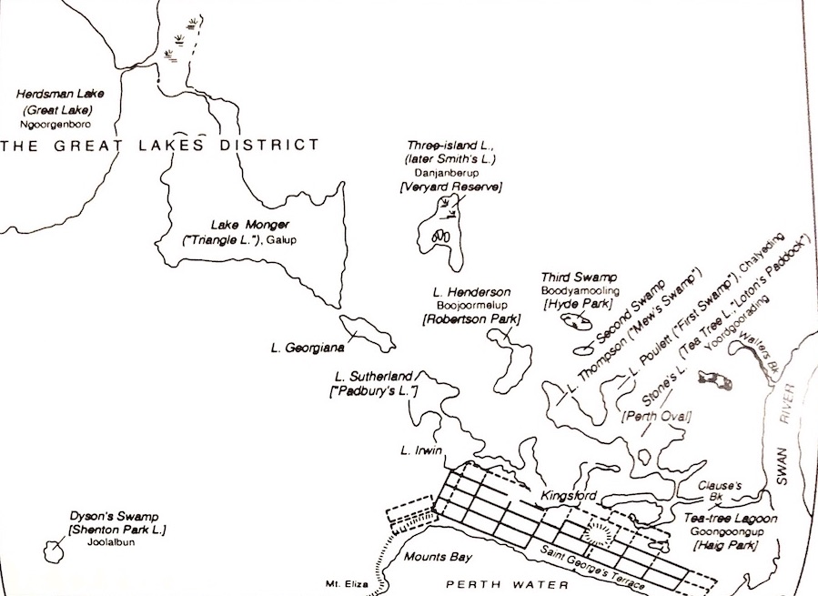
Fig. 1. Perth Lakes about 1830, at the end of the rainy season. The map is based on the Arrowsmith map of 1833, adapted by Margaret Pitt Morison, as first published in Western Towns & Buildings (M. Pitt Morison & J. White, eds., 1979), p. 14. Water surfaces would have shrunk considerably by the end of summer. The lakes' alternative names have been added, and land allotments omitted. [Tap/click for larger size.]
443
This article attempts an historical reconstruction of the transformation and almost complete obliteration of what used to be an intriguing, very significant and, for some people, embarrassing element of Perth’s landscapes, namely the many small lakes, basin swamps and marshes situated ‘at the back’ of the town. As the town expanded, some of these lakes were drained or filled and further lakes were reached. Gradually and fortunately, concepts of urban planning had in the meantime evolved towards a better understanding of the natural environment. Thus the ‘outer’ lakes—a few to the west, many north of the town and many south of the river—were preserved, albeit with almost unavoidable interference. They will not be examined here.
For thousands of years the lakes on the coastal plain 1 had provided Aborigines with water and food. They were particularly important to them during and soon after the long dry summer, which reduced most lakes to ‘nothing more than swamps’. 2 ‘The bulk of the diet comprised carbohydrate staples derived from fruits and seeds, bulbs and corms, underground root tubers, and starch-filled stems or rhizomes. Reed rhizomes, ground and made into “damper”, provided much of the daily bread.’ 3 The ‘flag’ [reed] yun-jid is at its edible best in April and May, and the rush jeeta in June. Frogs, normally buried in the mud in the summer, and tortoises, were an important reliable source of protein and fat. Swans and ducks, more or less plentiful according to the season, were caught by hand (at moulting time) or hit with spear or boomerang, or patiently snared with a noose. 4
James Stirling and Charles Fraser had reported in 1827 that the site of the future British settlement had abundant fresh water, but they had not actually seen any lakes or basin swamps. The initial site of Perth chosen in 1829 was constrained between Perth Water to the south and a chain of small lakes and swamps to the north, which for many years remained ‘the back of town’. Mount Eliza to the west and the Swan River to the east set firm boundaries to expansion. The obvious spaces for the growing of vegetables and for future urban expansion lay to the north, along and beyond the chain of lakes, which were increasingly viewed as a nuisance and an obstacle to development. For over fifteen years Lake Kingsford was full enough to impede the extension of Wellington Street west of William Street.
444

445
Most lakes were aligned in partly-linked systems. Just north of the main Perth ridge there were lakes Sutherland, Irwin and Kingsford in one complex; further to the west lay lakes Georgiana, Monger and Herdsman in what was known as ‘The Great Lakes District’. The northern system consisted of lakes Stone, Poulett (First Swamp), Thomson and Henderson. North of them lay Second and Third Swamps and Three-Island Lake. In the early days alternative names were used popularly, particularly with regard to land occupance, e.g. Mews’s Swamp or Lake for Lake Thomson, or Padbury’s Lake for Lake Sutherland. In referring to Perth’s lakes the term ‘lagoons’ appears in G. F. Moore’s diary, in which he wrote ‘... some of these lagoons ... which he [Kingsford] thinks have a communication with each other through the sandy soil, or which may be made to communicate with inexpensive cuts’. In Figure 1, Aboriginal and other names have been added to Pitt Morison’s reconstruction of the 1830 Perth plan, based on early records and the 1833 Arrowsmith map. 5
Many of these wetlands were interconnected and in wet seasons the waters joined up, finding their way into the Swan River at East Perth, through Claise Brook (originally named Clause or Claise Creek). Massive winter floods were already experienced in May-June 1830; unfortunately nobody could afford time to keep any objective records of water levels, but it is known that the Causeway Flats and surrounding country were under water for months. 6
Apart from some partial reclamation at Thomson Lake by Thomas Mews (‘Mews’s Swamp’), probably by land-filling to provide land for , vegetable growing, 7 little effort was made to reclaim swampy ground during the first quarter-century of colonization. In 1833 Samuel Kingsford erected at the foot of Mill Street a mill driven by water drained southwards from Lake Kingsford by means of a ‘deep open cut’, 8 ‘the Lt Governor agreeing to Mr Kingsford having the perpetual right made over to him of converting the waters of Kingsford Lake, Irwin Lake, Lake Sutherland and Lake Henderson for the use of a mill to be erected by him in front of the Bazaar Division of Perth ...’. The site is shown by a plaque in Mill Street.
By this time some attention was being given to fertile areas of the wetlands in the vicinity of Perth. In September 1836 applications had been made for land between lakes Monger and Herdsman, which was held in reserve in case of the possibility of connecting the two lakes ‘whenever such a measure might be required for supplying the town or any enterprise with water’. On 11 May 1837 Richard Wells had sent a request to the Governor for permission to purchase Lake Sutherland for the purpose of endeavouring to drain it and bring the land under cultivation. His aim was the production of summer feed for cattle because there had been so much demand for such fodder during the last summer. On 22 June 1837, the Surveyor-General requested that the Civil Engineer examine the reserved land between lakes Monger and Herdsman. He did so and found ‘that there is no part of the same [land] naturally adapted for the formation of a connecting channel between the two lakes; but if it should be decided
446
advisable hereafter to form that connection, the shortest and only practicable cut will be between the two connecting swamps ... the connection of the two lakes must of course be for the purpose of draining Monger’s Lake into Herdsman Lake, the latter being evidently much lower than the former. 9 The Surveyor-General later advised that it would no longer be necessary to continue the reserve of land in this area.
The 1838 map by Colonial Draftsman Hillman 10 shows most lakes unchanged, but subdivisions encroach on the south shores of lakes Kingsford, Thomson and Stone’s. With its longer-lasting groundwater, the lake area could supply plenty of well water to small holdings, mostly used as dairy farms and market gardens. However, Beaufort Street had been opened, and a deeper section of Lake Kingsford continued to hinder access from Barrack Street.
In 1842 floods from Lake Kingsford extended over and beyond the full length of Wellington Street. The Arrowsmith map of 1845 shows the Perth Statutory Plan based on the survey by then Assistant Surveyor A. Hillman. Lake Sutherland appears as completely subdivided except for a narrow diagonal line which led straight to Lake Irwin. No lake east of William Street appears on this map; land lots west of it abut on Lake Kingsford or even slightly encroach on it. Wellington Street (west) and Roe Street were not yet gazetted. 11
Heavy rains which began in April 1845 caused some floods, but worse was to come. Very heavy rains in the winter of 1847 caused Lake Kingsford to flood again, covering the recently gazetted Roe Street, as well as what is now Forrest Place, and parts of Murray Street. ‘In Murray Street, and all the streets in its rear, the water has risen so much as to compel the inhabitants to quit and seek for drier homes’, 12 rendering the street ‘nearly uninhabitable’. A deep open drain was hurriedly constructed on the north side of Wellington Street to drain off the surplus water along the faint gradient towards the east. There was some worry that any reclamation might reduce the supply of water to the rebuilt mill at the foot of Mill Street. 13
Surveys in 1847 of several lakes proposed to be drained noted that September-October was the time when they held the most water. The precision of these early surveys was admirable indeed, and well ahead of the knowledge of hydrology and hydraulics at the time. A committee appointed in 1848 to evaluate the policy of draining the lakes completely ‘both as a matter of health and revenue’ reported that ‘the consent of the land owners and occupiers on the Lakes Irwin and Sutherland being obtained, these lakes may be drained into Lake Kingsford to the depth of two feet [60 cm] above the present bottom level; which will tend to maintain the confined head of water in Lake Kingsford pure and constant, and increase the summer supply in the wells ... The swamps to the east appear mere lodgements of water, easily and beneficially removable by surface drainage to Claise Brook.’ 14 It should be noted that in the 1847 flood the tract between Barrack and Beaufort Streets again became utterly unfordable.
447
Not everybody agreed on the advantage of lake drainage. A leading article in a local newspaper quoted two medical authorities in support of the contention that drainage would cause ‘more noxious emanations than in their unreclaimed state’. 15 It is not clear whether the objectors referred exclusively to drainage, or to land-filling as well.
During this period and in the following decades the outer lakes, including lakes Monger and Herdsman, were left relatively undisturbed, but the moist land around them was subdivided into large blocks and used to grow dairy fodder and vegetables. ‘Lake Herdsman, being also at present remote from any part of the townsite available for occupation by the public, does not call for immediate attention; but when the time shall arrive for extending the building or suburban lots to it, the surface might then advantageously be drained or raised from the adjoining land.’ 16
On the borders of the lakes had been established summer market gardens which, when properly looked after, yielded plentiful crops of melons, potatoes, carrots and other vegetables. During the winter months, however, they were completely covered with water and utterly useless. The inadequacy of the 1847 drain, which had fallen into disrepair and had even been partly filled in 1852, was once again evident during the heavy rains of 1853, resulting in considerable damage to property and public outcry: ‘A large portion of the most valuable garden land is now useless and of the many allotments occupied, a large portion of them under water rendering them unfit to live on, although much expense has been incurred by the owners in building.’ 17
In March 1854 a special committee expressed the ‘opinion that the water in the lakes and swamps at the back of Perth from Lake Irwin to Claise Brook should be entirely removed by drainage, to avoid the danger of malaria and gain benefit from reclaimed land for gardens’. It was found, however, that reclamation by filling would be too expensive, and a barrel brick-lined drain was recommended instead. The Sutherland-Irwin-Kingsford lake chain was drained into Claise Brook, via Wellington Street and Water (now Royal) Street, but the real drain only began at Lake Kings-ford, into which were led the waters of the two upstream lakes. 18 This scheme had the effect of transforming what might be interpreted as an extended and superficial Claise Brook valley with very erratic seasonal flow into a subterranean channel with a seasonally variable flow. That the concept was sound in principle may be judged from the fact that, apart from small local changes of position and various serious setbacks due to inadequate capacity of the drains, the route of the present drainage system is still the same.
The complex swamps in East Perth were also drained into Claise Brook. Later that year, sales were announced of land lots ‘situated in the bed of what originally was Lake Kingsford ... drained and cleared of rushes’. 19 ‘A notification appeared in yesterday’s Government , that the drainage having been completed, the swampy lands in the townsite are reopened for selection, and the upset of the “rich garden ground” on Lake Kingsford is fixed at 25 pounds each lot.’ 20
448
Among government officials there was a general reluctance to acknowledge that the lakes imposed any restrictions to plans for future development, and a tendency to ignore them so far as possible. The map ol Perth in 1855, adapted from a plan containing additions and alterations signed in Executive Council by Governor FitzGerald, shows various improvements to street layout, while the names of more lakes and swamps are omitted. 21
For several years the drains were maintained partly as open cuts, and market gardens were thriving on the lake shores, but any excessive falls of rain had the effect of preventing the occupiers of lakeside allotments from cultivating their land for weeks or even months. The original drain answered its purpose well in the first instance as it only reached upstream to Lake Kingsford and was able to drain that lake as was originally intended. Later, however, when lakes Sutherland and Irwin, situated on higher ground, were drained through Lake Kingsford, it was found that the same drain had not been laid deep enough to carry so much water. 22 Furthermore, sand and all sorts of debris kept falling into the open drains. In the winter of 1856, ‘in consequence of the recent floods, property to a considerable extent has been destroyed in the swamp grants at the back of Perth’. 23 The reclaimed lots had produced ‘the greater portion of the vegetables consumed in the town of Penh during the summer months of the last two years’. 24
The inadequacy of the existing drainage system came to be even more widely recognised; holders of allotments on Lake Irwin forwarded a petition to the Colonial Secretary in July 1857 complaining about flooding in their locality, completely covered with water. In the winter of 1858 flooding again threatened landowners and occupiers: . excessive rains of this season have accumulated water in the Perth lakes faster than it can be carried off by the present trunking and drains to Claise Brook’. 25
The winter of 1862 brought ‘incessant rain for 3 weeks [and] the Great Flood in Perth ... At the rear of the city there was one vast lake; gardens, and in many cases houses, being completely within its influence ...’ The ‘vast lake’ extended from Murray Street north to Brisbane Street, leaving two or three buildings clear of water. 26 At last, in 1864, public works carried out by convict labour included the beginning of the reconstruction of the drain ‘at the back’ of Perth, along Wellington Street. The Governor decided that ‘convict labour may be employed in clearing and making good the drain between Irwin lake and Claise Brook, with a view to prevent in future the great loss we have sustained’. 27
General maintenance of the drain continued for some years, but it was obviously inadequate, even though it came to be known as the Main Drain. In March 1869, F. B. Barlee, Colonial Secretary, called for tenders for ‘clearing out and deepening the open drains, etc., connected with the drainages of lakes Irwin and Kingsford at Perth’. 28 In 1870 began the plans for draining of Lake Henderson through Lake Munro. 29
The winter of 1871 was exceedingly wet and caused extensive floods in the town, from Roe Street to Murray Street. The gales and floods
449
Fig. 2. Perth's ‘lost' lakes. The plan of Perth in 1903 drawn by Margaret Pitt Morison (op. cit.,p. 55) has been simplified and a few key street names have been added. The outlines of the former lakes have been added by dotted lines, so that each lake can be placed where it would fit in the 1903 plan. Each lake is given a distinguishing number, and all lakes are listed accordingly. [Tap/click for larger size.]

450
‘of unprecedented severity’ caused by the tropical cyclone of March 1872 caused more damage, mostly through the force of the wind. 30 Lake Poulett, the old ‘First Swamp’ (No. 8 in Fig. 2), was drained in 1872, serving for a time as the town rubbish dump and then being used by a group of Chinese as market gardens; it was partly used for the formation of Birdwood Square in 1914. Also in 1872 the Surveyor-General asked the Perth City Council to list the lots it wished to acquire for drainage or other purposes, including public recreation, which was becoming important. The Council in reply mentioned among others the lots needed for the draining of Second and Third swamps and Lake Henderson and the intended use of Third Swamp as a public garden. Tea-tree Lagoon was desired for a botanical garden and cricket ground. 31 It later became the Mulberry Plantation, which did not last long but was used as a public garden, and more recently Haig Park; by 1900 the site for the botanical garden was reserved further south, 32 where Trinity College is now.
Third Swamp (No. 10 in Fig. 2) was reserved in 1873. Originally thickly grown with paperbark trees, a camping ground for Aborigines and later homeless people, and a popular resort for duck shooters, it was reduced to two small formal lakes with minute refuge islands, within what in 1899 was named Hyde Park. 33 Three-Island Lake (No. 12 in Fig. 2) was reclaimed about the same time, and became a fairly large area of Chinese vegetable gardens. Later it was left as a swamp with considerable beds of rushes, until the City Council resumed it; its deepest part is retained as a small lake at the Fletcher Sports Pavilion.
In 1873 a petition from owners and occupiers of allotments near Lake Henderson (Smith’s Lake, No. 11 in Fig. 2) called for the re-laying of trunks in the drains. Lake Henderson, once a reedy swamp in an area along Fitzgerald Street, was drained in part to become the site of market gardens for many years. Perth’s Lake Thomson (No. 7 in Fig. 2, not to be confused with the present Lake Thomson, formerly Jilbup, in the Cockburn area), when drained in 1873, was also under cultivation as suburban location 28; its drain followed the alignment of Forbes Road. Some small industries that needed a relatively great deal of water, such as commercial laundries, were located in this area. Perth location 2 was on the site of Stone’s Lake (No. 6 in Fig. 2), and at one time it was known as Mr Loton’s Paddock, used as a cow pasture. Later this site became known as Loton Park, within which was placed Perth Oval.
By 1873 it was general opinion that the drainage problems of the more central Perth lakes had to be finally resolved. The Perth City Council held several meetings on the question itself, and on the estimated costs of possible solutions; it even debated whether new drainage channels from Lake Kingsford should be dug southwards along William or Barrack Streets, but eventually decided to follow the existing route to Claise Brook. 34 Contracts were let in mid-1874 (with Wellington Street again flooded) and work was completed more than a year later. Swampy ground from Lake Kingsford persisted along the north side of Wellington Street, from the present railway
451
station westward across William Street, to a fairly deep pond at the site of the present station. 35 This pond was filled in the early 1880s. 36 Swampy ground recurred in front of Perth Railway Station even during the 1890s.
Lake Georgiana (No. 13 in Fig. 2), although omitted from the 1855 map, existed as a shallow lake until the 1870s, for an uninformed proposal was made at that period to make it an additional source of Perth’s water supply. The idea was dropped and later the lake was drained to permit Newcastle Street to be continued westwards to Loftus Street. Lake Sutherland, closer to the city, became in part a small park at the corner of Aberdeen and Sutherland Streets (now occupied by the divided Mitchell Freeway). By 1875, following the disappearance of most of the original lakes and swamps within Perth’s boundaries, the only permanent urban lakes were the twin Hyde Park ones and a remnant of Smith’s (formerly Three-Island) Lake. The City Council had turned most of the former wetlands into gardens, parks and recreation reserves. The Perth Railway Station, originally to be built at Weld Square, was built in 1880 on the site of the reclaimed Lake Kingsford. 37 The railway goods yards, not far to the northwest [later the site of the Entertainment Centre] were established over the former Lake Irwin (No. 2 in Fig. 2).
The old lake sites were still subject to inundation. Through a combination of poor planning and construction, in 1882 Murray Street was ‘again flooded with tainted water’. In 1897-98 the drainage system was upgraded, but by mid-1899 the main Wellington Street drain was nearing collapse. The Perth City Council began to replace open-cut and shallow drains with new drains laid 7 feet (2.1 m) deeper and with about three times the capacity. 38 The diameters were ‘5 ft 3 in. [1.6 m] from William Street to the corner of Nash and Small Streets, 7 ft [2.1 m] from there to the corner of Lord and Royal [formerly Water] Streets and 8 ft 6 in. [2.6 m] from there to Claise Brook’. By 1904 the drain had been extended westwards to Melbourne Road (now Milligan Street). 39
By the end of the century the small Dyson’s Swamp at the western end of Subiaco and in the new subdivision of Shenton Park had been renamed Shenton Park Lake. Pitt Morison’s map of the City of Perth in 1903 (Fig. 2) shows the urban and suburban expansion that followed the gold rush. 40 Significant extensions were made to the drainage system after it was taken over by the Metropolitan Water Supply, Sewerage and Drainage Board (now Water Authority of Western Australia) in 1907. The same year an intercepting 2 ft 6 in. (76 cm) drain was built from near Glyde Street eastwards to take any excess water from the main drain before it entered the open remnant of Claise Brook, which always had inefficient water circulation.
A branch of the Claise Brook Drain to serve the North Perth area was built in 1908. It joined the main drain at Lord Street, following Parry and Stirling Streets where it met its two branches, the one from Robertson Park (Lake Henderson, No. 11 in Fig. 2) and the other flowing from Hyde
452
Park through Birdwood Square (the former Lake Poulett or First Swamp, No. 8 in Fig. 2). The first branch was extended in 1911 to drain Smith’s Lake (No. 12 in Fig. 2) along Charles Street north of Vincent Street. The Perth City Council bought the former lake area and reclaimed it further by draining, rubbish-tipping and land-filling, to provide building lots.
The Mounts Bay Drain, draining Lake Monger into the Swan River, was built in three sections, proceeding uphill: from the river to Wellington Street in 1907, Wellington Street to Sutherland Street in 1908, and Sutherland Street to Lake Monger in 1909. It now drains the areas originally covered by Lakes Sutherland and Georgiana (Fig. 1, and Nos 1 and 13 in Fig. 2). The Perth City Gasworks were built on the ‘public gardens’ just north of Claise Brook in 1914, and, in 1929, Tea-tree Lagoon was finally filled in. Its north bank was then used for industrial buildings. 41
At the end of 1947 the open Claise Brook was still ‘trained by wooden sides and struts laid at intervals across the top, [work which] was done during the Depression. At the outfall the drain is fringed with rushes backed by a clump of castor-oil [shrubs], to the north are the Gasworks, to the south of the outfall are the remains of an old wooden wharf, and behind this is a sewerage pumping station. Water was flowing down the drain and we noted Blue Herons, Silver-eyes, Senegal Dove, Willy Wagtail and Gerygone [ = Western Warbler] singing.’ 42 The planned redevelopment of part of East Penh includes the excavation of Claise Brook and the consequent re-laying of the terminal part of the Main Drain. This re-establishes a free water surface and a deeper body of water where Claise Brook and Tea-tree Lagoon had been, with the expectation of significant differences in the quality and movements of the water.
The lakes at the rural margin of the earlier townsite or just within the Perth Road Board District (now the City of Stirling) were unaffected by settlement for a much longer time. Herdsman Lake was as yet unnamed and marked ‘large open swamp’ and Lake Monger, also unnamed, ‘open swamp’ in the first sketch map of land allocations at the Swan River Settlement drawn by Roe, the Surveyor-General, in 1829. Herdsman Lake soon became ‘The Great Lake’ for the colonists. Situated only 7 kilometres north-west of Perth, it was a favourite resort for duck shooters. The committee that investigated metropolitan lakes in 1848 reported that ‘the natural drainage of Herdsman’s Lake (which is 1IV2 feet [3.5 m] below the level of Monger’s) being to the Northward and Westward, no objection would appear to such drainage of that shallow lake as would render its recovered surface of 1057 acres [427.75 ha] arable.’43 Lakes, and to some extent swamps, were significant landmarks. In 1871 the Perth Road Board declared main and minor lines of roads, the latter going ‘to Herdsman Lake and from there to a junction with the main north line at Jackadder ... and also from the main north line, westward between Carine and Balcatta to the sea. A further minor line led northwards from Freshwater Bay, through Butler’s Swamp.’ 44 Another road passed south of Lake Monger to reach small farms west of Herdsman Lake. 45
453
The ‘Great Lakes’ and the much smaller Jackadder Lake are wetlands which still survive, although they are much altered by drainage, filling and ‘development’, notwithstanding some inquiries and reports dating from the first half of the century (mentioned at their chronological place in the first part of this article). About 1912 some of the swamps in Osborne Park were privately and somewhat superficially drained, the channels being led into Herdsman Lake. The swamp now named Ngurgen Boro, not to be confused with the Aboriginal name of Herdsman Lake, was the largest. The success of this drainage scheme, which allowed some groundwater to persist through the dry season, encouraged moves for the reclamation of Herdsman Lake, as mentioned in the 1848 report.
Preliminary observations for a major drainage scheme of the lake were made in 1919, when 21 bores were sampled by the Public Works Department. Drainage works were commenced in March 1921, and the main drain was operating by May 1925. Provision was made for subsoil irrigation using drainage water from the Osborne Park drains, the flow being controlled by means of locks. 46 The drainage scheme included a 3.2 km tunnel from a drain leading out of the lake to the ocean outlet near Floreat Beach; it was completed in 1928 and the tunnel was improved in 1947-48, a century after the formal mention of the idea.
Had it not been for the drainage scheme, the extent of open water in Herdsman Lake would most likely have increased soon afterwards, 47 during the few wetter years that followed. It was unfortunate that disappointing results were obtained when settlers tried to establish market gardens on the reclaimed land, particularly on the black, crumbly peat on the western side, where nothing could grow. Teakle 48 doubted whether the soils of Herdsman Lake could be made economically productive under crops, and recommended grazing as a suitable land use.
For some years the lake bed was used in part to grow pasture for dairy cows. Finally, in October 1976, a Concept Plan was adopted by the Metropolitan Region Planning Authority, suggesting that Herdsman Lake be retained as extensive public open space and compensating basin to collect stormwater drainage from adjacent suburbs. Currently parts of the lake’s shores are devoted to market gardening, horse raising and riding, and close residential developments (‘villages’ and blocks of units) inside the former western margin. The considerable changes in land use which have occurred in the northern part of Herdsman Lake, the eastern margin of Jack-adder Lake, Ngurgen Boro and the southern part of the main Osborne Park swamps are best shown by successive aerial photographs, 49 which are a most objective source material for the contemporary history of this field.
According to the plan, the lake retains a partly interrupted dredged inner ring of free water to provide a protected environment to the many species of water birds that live in the interior, and protected, swampy sedgeland. Fires frequently occur in summer in the dry bulrush beds. The present conditions of the lake have been studied and are described in detail, with a recent map. 50 Osborne Park’s and Jackadder’s drain comes from the north,
454
Fig. 3. The march of 'progress'. The map shows the gradual growth of the artificial drainage network and the reduction in the area of lakes and swamps. Several dates along the same drainage line show that significant work was done at different times, but without changes in the actual route followed; dates are tentative because in many instances several years passed between the planning and approval stages and the beginning and completion of the same work. The trench leading water to Kingsford’s mill and the site of Reveley’s excavated tank and mill race are also shown. [Tap/click for larger size.]

455
Balgay Road’s from the east, Herdsman’s own Inner Ring’s, Selby Street’s and others from the south to join within the western margin of the lake and continue westwards as the Herdsman Main Drain.
Jackadder Lake has been made more accessible by works more complex than would be conveyed by a brief description such as: ‘an open space water area has been defined by filling round the perimeter, and the water area cleaned of various water types of growth and other unwanted material’. 51 ‘It is understood that people who live near the lake consider that fringing vegetation obscures water views, provides shelter for vandals and traps litter.’ 52
Lake Monger, the smaller ‘Great Lake’ of early days, had never really been a very large sheet of water, but had been surrounded by very broad swampy shores (Fig. 1) which had gained for it the name of ‘Triangle Lake’. Contrasting views of the lake in two different seasons were given in an early settler’s description: ‘... at the close of summer ... the trees appeared half-burnt, or, if they had escaped fire, quite dried up, and devoid of moisture. The banks of the lake, certainly were of sand, but without the slightest appearance of shell or pebble ... where water should have been ... there appeared nothing but black mud and cracked into a close resemblance of the meshes of a net by the heat of the sun. The only place where I saw any water was just in the centre, where a small stagnant pool of about a hundred yards in circumference [29 m in diameter], appeared fast evaporating like the steam from a shallow vessel of boiling water.’ Later, in June, ‘the lake had then water in it, covering the whole of its surface, the underwood, instead of the dry, miserable scrub, presented a carpet of the most exquisitely beautiful flowers, and even the mahogany [jarrah] trees appeared as if they would wish to be covered with bright foliage ... it is astonishing in winter what a quantity of game frequented the neighbourhood of these lakes, when, during a summer visit, everything appears barren and unpromising.’ 53 Aborigines then used to camp on the drier western and southern shores.
In 1848 it had been recommended that ‘Monger’s Lake might effectively be drained through Lake Herdsman’. 54 A large swampy area in the southeastern part of its shores was partly filled in and already subdivided into large lots in the 1870s. 55 The actual move to control the lake level was not made until 1909 with the construction of the Mounts Bay Drain.
By the 1920s Lake Monger had become a fairly constant and well-controlled, if much smaller, body of water (cf. Figs 1 and 2). Some Aborigines still camped near it. Old inhabitants of Leederville remembered the prolific bird life of their early days, when flocks of flying ducks or swans were ‘so great at times that they clouded out the sun’. (Could this have been the assembling of large flocks prior to migration time? Such assemblies, probably less numerous, have now moved to other, less disturbed lakes.) The stands of tall reeds and rushes gave the birds plenty of shelter for their needs. The lake was a very popular resort: there were ‘Sunday afternoon yachting regattas, with as many as 12 yachts and other small
456
crafts, on the restricted stretch of water’. A large boat shed had been erected. 'Oarsmen on Lake Monger could get in a solid row over a straight three-quarter mile [ 1,200 m]... water depth varied from 14 feet [4.27 m] at the north-west, or Glendalough Street corner, to a few feet [perhaps just above 1 m] at the south-east bank.’ 56 On the western side were two bathing sheds adjacent to a T-shaped jetty, and two diving platforms about 20 metres offshore.
In 1936 it was realised ‘that the whole of Lake Monger [was] a breeding ground for the midge pest’ which reproduced by the million and could not be stopped by ordinary fly screens. Spraying campaigns were carried out. The lake environment was also greatly altered. Large stretches of reeds have been covered and replaced by lawns, playing fields and gardens. A fatal accident just before World War II led to the prohibition of boating on the lake. Swimming was also discouraged, and the lake lost much of its popularity. To make things worse, the open water was rapidly invaded by the floating exotic water hyacinth Eichtornia crassipes and thorough spraying to poison it had to be carried out. On the other hand, the great reduction in the use of the lake by humans increased its appeal for water birds, probably attracted by sympathetic hand-feeding. In June 1958, while some 20 acres [8 ha] of land at the northern end of the lake were being reclaimed with city refuse and sand, there were ‘fish of many kinds, and it [was] estimated that there [were] 600 Black Swans and thousands of ducks and other birds on the lake ... '. 57
Later, serious problems began to arise. In June 1961 several hundred carp (an introduced but thoroughly acclimatised fish species) died from oxygen starvation. Two years later, local residents criticised the Perth City Council for creating a health hazard in the industrial rubbish tip along the lake’s western shore: ‘no matter which way the wind blows there’s always something in the air round Lake Monger—flies, mosquitos, blowflies, dust and with it all a nauseating stench’. 58 At present, extensive reclamation has completely altered the landscapes of the past, replaced by introduced Norfolk Island pines and cultivated lawns. Swans breed in the sheltered environment of Herdsman Lake and then escort their families overland to Lake Monger, where food handouts are assured. Ducks, ready to commute by flight, are usually quite numerous. Carp grow to a large size, undisturbed at the bottom of the water. 59 More recently there were complaints of a bad smell, and investigations showed that ‘the nutrient enrichment in the lake, caused by the run-off from fertilised lawns, was excessive ... toxic algae and midge swarms had [again] developed ... Groundwater contaminated by sanitary landfill seepage and septic tanks had affected the lake ... sediments and fecal material from waterfowl swelled the nutrient levels.’ 60
Further west, Butler’s Swamp, 61 considerably reduced in size but now with artificially maintained permanent water, has become Lake Claremont, with playing fields and a golf course on its shores. It is attractive for humans, but has lost most of its value as a natural habitat, and is probably receiving too many plant nutrients in the drainage and run-off from surrounding gardens and lawns.
457
There are other lakes within the Perth metropolitan area, further away from the city and subject to much more recent utilisation, and consequently far less endangered by voluntary or involuntary hostile human pressure. Furthermore, nowadays a lake environment is more likely to be appreciated and its balanced management better understood. The threat is much greater for the swampy shores of the lakes and for any independent basin swamps, mostly covered by stands of paperbarks and patches of sedges or reeds. The human eye appreciates a free water surface, but a balanced natural environment comprises more or less concentric zones of different types of vegetation, needed for the life of the different plant and animal communities. When natural areas of reeds and paperbarks are removed, many birds, amphibians and reptiles are deprived of places in which to breed and shelter.
The ‘beautification’ of Lake Monger has led to the decrease of its habitat diversity and a fall in the number of plant and animal species present; once surrounded by stands of paperbarks and containing extensive reed beds, it has been reduced to a steep-sided, open-water area surrounded by lawns. This has removed roosting and nesting sites and greatly reduced the shallow littoral zone which biologically was its most productive part. However, both lakes Herdsman and Monger are rated of major importance as drought refuges for water birds. 62
In 1966 it was estimated that 75 per cent of the wetlands of the coastal plain (including streams as well as lakes) had been lost. 63 In the City of Perth the loss probably nears 99 per cent. Let us hope that the sad history of the Perth lakes will not be repeated elsewhere by future generations, and that these ‘lost lakes’ may live in our memory. Their ‘presence’ is still a reality: any plan to sink the railway and take it underground past today’s Perth Railway Station must take into account a potential, albeit partial, revival of Lake Kingsford, whose soft muddy southern shore had to be pierced by countless timber piles before the General Post Office could be built. After a very rainy winter, water from Lake Kingsford had to be pumped from the basement of Boans (now Myer’s) store. The much later reclamation of Smith’s Lake (Three-Island Lake, in North Perth) also left a bad legacy: the houses of 14 people in Kayle Street have suffered structural damage, in some cases very serious, presumably by failure of the in-filled ground underneath. 64
A more insidious danger threatens the lakes at present: increasing pollution. The most widespread cause is the gradual accumulation of diluted pesticide, weedicide and fertiliser solutions from surrounding gardens. Fertiliser increases the amount of nutrients in the water (eutrophication process), leading to a gross increase in the number of some plant species, overwhelming and at times eliminating other plant and animal competitors. On Lake Monger the hand-feeding of birds, particularly black swans, has attracted such increased numbers that their manure contributes noticeably to the eutrophication of the water. Underwater decay of cast-off feed (mostly bread) and bird manure, in addition to the previously
458
poisoned and sunk water hyacinth, provide a fertile ground for the multiplication of the anaerobic bacillus Clostridium botulinus, which causes the outbreaks of botulism that kill many birds and fishes which eat infected food, particularly in late summer when other food is scarce.
On the positive side, State Government legislation passed in January 1993 simply forbids the filling in of wetlands. On the local scale, the Claisebrook Valley development plan recently published by the East Perth Redevelopment Authority 65 proposes to free Claisebrook Inlet as far west as Plain Street. There will be a landscaped park and a habitat island on the south shore. Water circulation will be aided by the straight banks, particularly along the north shore; unfortunately, such straight banks are nearly barren as biotic habitats. As to Lake Monger, a 5-year management plan just adopted by the Perth City Council provides for some control over inputs into the lake and, inter alia, for consultation with Aboriginal groups named from time to time by the Museum’s Department of Aboriginal Sites.
REFERENCES
1. An excellent comprehensive map showing all lakes on the coastal plain (Wetlands of the Perth to Bunbury Region, mapped by V. & C. Semeniuk Research Group) was published by the Water Authority of Western Australia in 1992.
2. F. S. Brockman, ‘Physical Features’, in M. A. C. Fraser, Western Australia Year Book 1902-04, p. 97.
3. Sylvia J. Hallam, pers. comm., 1991.
4. G. Grey, Journals of Two Expeditions of Discovery ... (Facsimile ed., Libraries Board of South Australia, Adelaide, 1964), Vol. 2, pp. 283-4, 294.
5. J. Arrowsmith, 1833. Plan of Perth from ‘documents furnished to the Colonial Office by J. S. Roe, Esq., Surveyor General’ (inset in map of Discoveries in Western Australia); redrawn without suburban subdivisions for D. C. Markey, ‘Pioneer Perth’, Ch. 15 in J. Gcntilli (ed.), Western Landscapes (Nedlands, 1979), p. 350; and by Margaret Pitt Morison for M. Pitt Morison and J. White (eds), Western Towns and Buildings (Nedlands, 1979), pp. 14, 16. The map drawn by Pitt Morison ‘from original plans in the Department of Lands and Surveys' (Jnl & Proc. R.W.A.H.S. 1: 82, 1930) shows no water link between lakes Sutherland, Irwin and Kingsford, perhaps indicating summer or intermediate lake conditions.
6. Bureau of Meteorology, Results of Rainfall Observations made in Western Australia ..., Government Printer, Melbourne, 1929, p. 94.
7. C. T. Stannage, The People of Perth (Perth, 1979), p. 49.
8. P. Hasluck & F. I. Bray, ‘Early Mills of Perth’ (Jnl & Proc. R. W.A.H.S., 1: 62, 1930).
9. Colonial Secretary to Surveyor-General, April 30, 1833; CSO Vol. 48, p. 49; CSO Inward Files, 1837; CSO Vol. 54, p. 99.
10. A. Hillman, [Plan of) The Townsite of Perth, Western Australia, from an actual survey.
J. Arrowsmith, London, 1838. (City section reproduced in D.C. Markey, op. cit., p. 354.)
11. A. Hillman, Town of Penh [map], Perth, 1845. (City section reproduced in D.C. Markey, op. cit., p. 355).
12. Inquirer, 11 June 1845, 11 August 1847.
13. Perth Gazette, 28 August 1847,4 September 1847.
14. CSO Records, Public Works, 9 May 1848.
15. Inquirer, 26 October 1853, 5 July 1848.
459
16. M. Pitt Morison, op. cit., p. 24; CSO Records, Public Works, 18 May 1848.
17. M. Pitt Morison, op. cit., p. 32; CSO Records, G. Shenton, Chairman of the Town Trust, 31 August 1853.
18. M. Pitt Morison, op. at., p. 24.
19. Government Gazette, 7 November 1854.
20. Inquirer, 2 August 1854. £25 [$50] may seem cheap when compared with today’s city land prices, but was in fact much dearer than current prices at the time.
21. M. Pitt Morison, op. cit., p. 33.
22. H. Wray, Acting Comptroller General to Colonial Secretary, 5 September 1856.
23. Inquirer & Commercial News, 27 August 1856.
24. Petition to the Governor by 28 owners and occupiers, 1856.
25. J. S. Roe, Surveyor-General, 29 August 1858.
26. Bureau of Meteorology, op. cit., pp. 94, 129; Perth Gazette, 11 July 1862, C. T. Stannage, op. cit., p. 146.
27. I. S. Hampton, Governor, 18 November 1862.
28. Government Gazette, 16 March 1869.
29. PWD, 21 November 1873.
30. Bureau of Meteorology, op. cit., pp. 168-9.
31. C. T. Stannage, op. cit., p. 167.
32. M. Pitt Morison, op. cit., p. 44.
33. ibid.
34. C. T. Stannage, op. cit., pp. 168, 169.
35. J. E. Hammond, plan of Perth 1871-72, in Stannage, op. cit., end paper.
36. PWD plan 4108, 1900.
37. M. Pitt Morison, op. cit., p. 43. The only Perth lakes shown on the same author’s map of Perth in 1883 (op. cit., p. 46) are the residual Hyde Park and Smith’s ones. A "plan showing the more populous portions of the City of Perth’ in 1885 shows no lakes south of Vincent and Bulwer Streets.
38. C. T. Stannage, op. cit., pp. 181, 280.
39. Interview of Dr D. L. Serventy with F. L. W. Morison, of the Metropolitan Water Supply, Sewerage & Drainage Department, 17 October 1946, in Battye Library.
40. M. Pitt Morison, op. cit., p. 55.
41. D. L. Serventy, personal papers, c. 1970.
42. J. Gordon, prize-winning essay published in part in the West Australian, 1974.
43. CSO Records, Public Works, May 1848.
44. L. A. Easton, Stirling City (Nedlands, 1971). Butler’s Swamp is mentioned in detail in Jenny Arnold, Perth Wetlands Resource Book, Ch. 8, Wetlands of the Western Suburbs, pp. 215-21
45. M. Pitt Morison, op. cit.y p. 43.
46. L. J. H. Teakle, ‘Report on Herdsman Lake’, 1935 (Battye Library, PR262).
47. B.L. Southern & L.J.H. Teakle, ‘A Soil Survey of Herdsman Lake’, J. Dept. A W.A.y 14: 404-24 (1937).
48. L.J, H. Teakle, op. cit.
49. Jenny Arnold, Perth Wetlands Resource Book, Ch. 8, Wetlands of the Western Subt (Bull. 266 of the Environmental Protection Authority), pp. 192-7.
50. D.R. Scott, ‘Evolution of a landscape—Manufacturing', in j. Gentilli, op. cii.. 470-1.
51. L. A. Easton, op. cit.
52. Jenny Arnold, op. cit.y pp. 188-92.
53. Swan River News, 1 August 1847, pp. 161-2.
54. CSO Records, Public Works, 1848.
55. Map of Perth and surroundings in 1877, redrawn by M. Pitt Morison, op. cit., p.
56. West Australian, 10 December 1949; Sunday Timesy 13 August 1969,
57. West Australian, 23 December 1936, 6 June 1958,
58. Weekend News, 5 October 1963.
59. Lake Monger is discussed in some detail, with references, in Jenny Arnold, pp. 197-202.
460
60. From a report by Murdoch University and comments by Peter Luff, Perth City Council’s controller of parks, gardens and landscape, quoted in Sunday Times, 11 October 1992.
61. G.A. Evans & N.V. Sherlock, ‘Butler’s Swamp, Claremont’, W.A. Naturalist, 2:152-60; Jenny Arnold, op. cit., pp. 215-21.
62. [W.A.] Environmental Protection Authority, Bulletin 374, p. 47 (1990).
63. T. R. Riggert, A Study of the Wetlands of the Swan Coastal Plain, Department of Fisheries and Fauna, Perth.
64. Sunday Times, 5 July 1992, 18 July 1993.
65. East Perth Redevelopment Authority, Claisebrook Valley Development Plan, c. 1991.
Garry Gillard | New: 19 April, 2021 | Now: 11 June, 2021